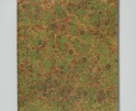
Kiana Hayeri: No Woman’s Land
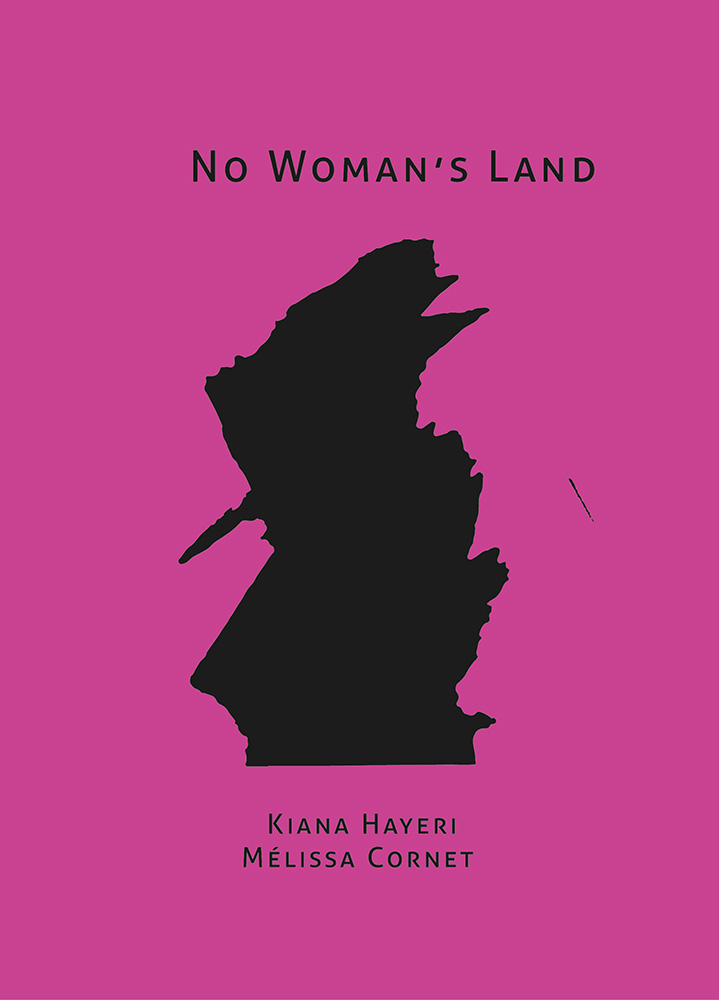
© Kiana Hayeri for Fondation Carmignac, Cover for No Woman’s Land
I first became aware of Kiana Hayeri’s work in 2020 when the New York Times Magazine featured her photographs of women incarcerated in Afghan prisons for killing their husbands. I was immersed in my own long-term project photographing women in New York State who had been convicted of homicide, and, in the two decades I was a public defender, I had represented many women who had killed their abusers. So I felt a natural affinity for Kiana and her work, and I’ve been following her ever since. I loved her first monograph, When Cages Fly (Raya: 2024), a gorgeous and captivating look at women incarcerated in Afghanistan, and I am blown away by the beauty, depth, and compassion in her new book, made in collaboration with Mélissa Comet, No Woman’s Land (2025).
I really enjoyed our conversation one Brooklyn morning, where Kiana in Sarajevo and Mélissa in Kabul had a little downtime. Just a few days later, the U.S. bombed Iran and our conversation would never have taken place: Kiana was covering the conflict; Mélissa was stranded in Dubai.
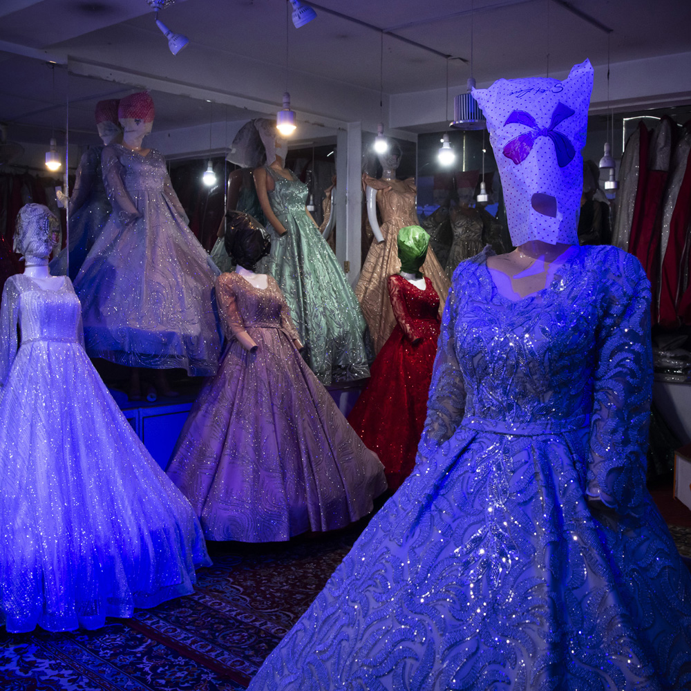
2. Kabul, Afghanistan. February 6, 2024. Mannequins covered in plastic reflect the ban on showing any representation of women in public. © Kiana Hayeri for Fondation Carmignac
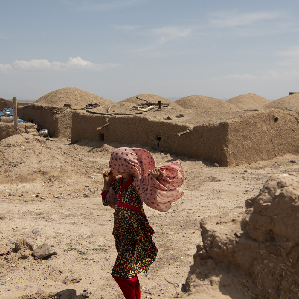
In 2024, photojournalist Kiana Hayeri and researcher Mélissa Cornet travelled through seven provinces in Afghanistan to document the lives of women and girls under Taliban rule, which, according to Amnesty International, could constitute a possible crime against humanity of gender-based persecution. They spoke with more than 100 women and girls barred from going to school and confined to their homes, journalists and activists continuing to fight for their rights, mothers watching history repeat itself for their daughters, and LGBTQI+ individuals whose existence is erased in silence. They documented the Taliban’s systematic dismantling of women’s most fundamental rights: to education, to work, to freedom of movement, to leisure, and even to spaces as ordinary as parks or beauty salons.
No Woman’s Land draws on this fieldwork to create an intimate portrait of what women’s daily existence has become in the wake of rights being stripped away. Structured in chapters, it offers exclusive, never-before-seen photographs, enriched with archival images, Polaroid artworks, sketches, and collaborative art made with Afghan artist Fatima Bahnia and Afghan teenage girls. It also provides extensive supplemental material including historical context, archival documentation, and information on the situation of women’s rights in Afghanistan.
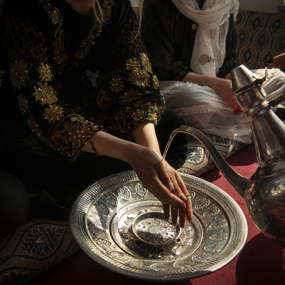
Kabul, Afghanistan, February 23, 2024. Guests washing hands before lunch at a small birthday party. Even small gatherings become acts of courage. © Kiana Hayeri for Fondation Carmignac
Sara Bennett: It’s very fitting that this interview will be published on International Women’s Day. I always lament what has happened to women’s rights in the United States in the past decade or so, but that pales in comparison to what women face under Taliban rule. Can you tell more about how No Woman’s Land came about and your collaboration?
Mélissa Cornet : Kiana and I met in Kabul in 2018, but we had never worked together. It turns out that we’d both seen a call for a proposal by the Carmignac Foundation for the 14th edition on women’s rights in Afghanistan and we both thought about contacting the other to see about collaborating. Kiana ended up calling me first and said she wanted to talk to me about something work-related and I said I had something I wanted to talk to her about that was also work-related. It was a coincidence and it also felt very natural.
Our backgrounds are different. Kiana is a fantastic photographer and at that point she’d been working in Afghanistan longer than I had. I’m a lawyer by training, with a focus on human rights and women’s rights, so it was very complimentary.
I also do a lot of sketches on the side, which is something we could bring in.
Kiana Hayeri: Both Melissa and I have lived in Afghanistan for a long time. And we had a quite extensive network of people, but funny enough, very different because each of us were in different circles. Melissa had access to a lot of NGOs, and I had a network of people I had met throughout the years.
At the start of the project, we put down an archetype of all sorts of women we would like to meet: a teacher, a student, somebody who worked for the parliament, a mother of someone in the Taliban. And then we started reaching out to our networks, letting them know who we were looking to interview and photograph. And because the introduction came from somebody they knew, we went in with an element of trust which was very, very helpful. And we worked our way from there.

Drawing by Mélissa Cornet
SB: I’m curious to know how you work. Do you go into the women’s and girls’ homes? Do you spend a lot of time with them? Do you bring your camera out right away? Is it just a quick shoot or do you spend a lot of time? From where I sit here in Brooklyn, New York, I would have imagined a lot of people wouldn’t have wanted to be photographed, that there would be an element of fear.
KH: There was definitely fear. For every 20 doors we knocked on and 20 people that we reached out to, probably 17 or 18 people said no.
So there was a lot of asking, asking, asking, asking to get access. It really varied how much time we spent. In some provinces or especially if we were embedded with an NGO, we had a very short amount of time, anywhere between 15, 20 minutes. But then there were people we spent a day with or people we returned to several times. Some of the most intimate scenes are at house parties or birthday parties. We built a relationship with these young girls over weeks and weeks. So they trusted us enough to take us home and to protect their identities.
SB: How are you protecting their identities? Some people are pretty recognizable.
MC: A lot of the portraits play with fabric and light and silhouettes but each use of the photo comes with different risks. We make different selections, depending on whether the images are for an online publication that has no paywall or for a photo book that in the end, you know, a few hundred people will read, or hanging on the wall in an exhibition.
We also had to figure out how much a woman would be at risk, how much she understands that the photo could end up online. Even though a woman might have wanted to use her face, name, and location, the situation could change so quickly and it continues to degrade so quickly that we had to be more conservative.
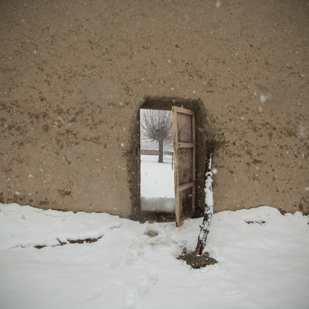
Patkheyl District, Zabul, Afghanistan, February 26, 2024. In heavy snow, a mobile health clinic reaches isolated villages. © Kiana Hayeri for Fondation Carmignac
SB: Those are the same kinds of considerations I have made in my own work, because there are a lot of future consequences that I’m aware of because of my experience as a defense lawyer, but the women I photograph may not be.
MC: It’s something we’re very aware of. It’s almost five years after the fall and things are getting worse and worse by the day. We’ve seen how the media tends to portray Afghan women. It was important for us to be fair and nuanced, meaning it’s very easy to blame the Taliban.
If you don’t talk about the role of the West during 20 years, and then also having completely crashed the economy through sanctions and freezing the assets, for example, if you don’t talk about the fact that it’s an extremely patriarchal society, regardless of the Taliban, if you don’t talk about climate change, then you’re not being fair.
So it’s not a surprise what the women say. The Taliban themselves say that girls don’t go to school.
At our exhibition in Paris, people were quite surprised to see beautiful, colorful photos. I think they expected women in burqas, you know, begging.
The photos show Afghan women in a different light. They deserve to be shown with dignity and empathy.
SB: I think that’s the power of the book. You do that so well. What about yourselves? Are you ever in danger?
MC: No, but we were very careful designing our security protocol and especially our e-security, how we store the data, the photos and the text.
SB: Melissa, tell me about the drawings that you made.
MC: There are non-photography visuals.We collaborated with an Afghan artist, Fatima Bahnia, and we worked on the topic of the dream. What are Afghan girls dreams? What do they want to become?
We took photos and then Fatima—she’s also an art teacher—-completed the story of the dream. So we use these to illustrate all of the different chapters, which are organized by verbs, by action.
And then some of my sketches are included as well. It’s something I started doing after the fall of Kabul, kind of trying to make sense of what was happening around me and going back to a country that both didn’t change, but also completely changed, where all your friends are gone.
But we also used some of the drawings as a way to capture some scenes that potentially couldn’t be photographed. For example, even though a wedding party is segregated, you cannot take any photos because it’s a very safe space for women. So we used archival images and Polaroids.
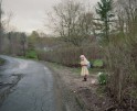
Enjil District, Herat, Afghanistan, April 23, 2024. A girl walks through rubble months after an earthquake devastated her village in Herat province. © Kiana Hayeri for Fondation Carmignac
SB: I love how that brings in a little playfulness. Also, I couldn’t help but notice the colors and lighting.
KH: The opening of the book has a lot of night scenes in Kabul. You see ice cream shops, a pizza shop, street food and all of them have neon lights. So we figured if we weren’t able to meet women in public spaces and we’d only be meeting at their homes, our homes, or our offices, then we’d bring that neon light, that outdoor sense, to the scene.
I was inspired by a couple of films that my partner, Jordan Bryon, had made, using a lot of neon lights. I started seeing Afghanistan in neon. And it’s so different from how Afghanistan is usually portrayed—either black and white or these monochrome style, a very yellow warm.
So we wanted to do something very different. And it was really nice because if you’re working for a newspaper or magazine, you have some restrictions, you can’t bring neon lights to the scene, but here we had the creative freedom.
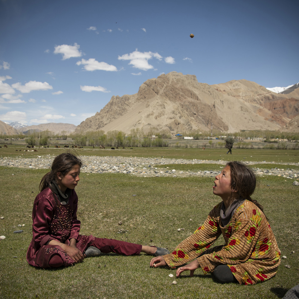
Badakhshan, Afghanistan, May 08, 2024. Masooma (8) and Zeeba (9) play 5 stones while herding sheep. © Kiana Hayeri for Fondation Carmignac
SB: Can you tell me more about the making of the book itself? Your book is so beautiful and powerful and the cover is really going to pop on bookshelves—the color is so vibrant. Are you happy with it?
KH: Yes, very happy. The quality is fantastic. It’s nice to have a book where you know that you did the whole process from A to Z. It’s been a real team effort.
MC: We just spent so much time looking at everything and brainstorming and designing it together with our designer, Santiago Escobar-Jaramillo. It feels really good to have a product that you’re 100% happy about.
KH: I personally learned from the first book, which I also did with Santiago. We did it remotely and it took a very long time. This time, the three of us got together in one space in France. We printed 300 to 400 photos and laid everything out—on couches, tables, everywhere. The concept and first draft came together over the course of three days and then there were a couple of other calls remotely where we fine tuned it.
The printing part was the most challenging because neither Melissa or I are book designers or understand the language to deal with this. So we left that to the designer and the print house in the Netherlands. And we really, really, really owe it to NPN printing. They went beyond and above in the amount of effort they put into it.
We did have issues with our cover, probably because it was printed elsewhere. There was a miscalculation and the cut out was off center, but we only noticed it when the cover came and the books started to be glued to the cover. So we had to reprint the covers.
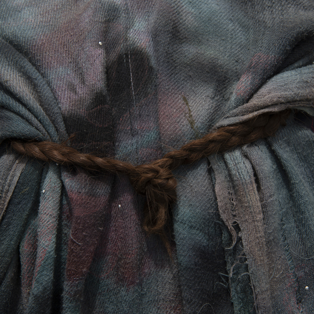
Zibak, Badakhshan, Afghanistan, May 10, 2024. Braided hair, quiet defiance in plain sight. A symbol of care, continuity, and dignity. © Kiana Hayeri for Fondation Carmignac
SB: Did you go on press?
KH: We hired a lithographer. If I want to give a little advice to anyone who is self-publishing, it’s to hire a lithographer. It makes a huge difference, especially if you’re not on site. But even if you are, I think ordinary photographers don’t understand the CMYK world and that should be done by a professional. Yes, it’s extra money, but it will make a difference.
The book is co-published with Raya. We had a fantastic printer and then we have a distributor, Mehdi Meghdadi, an amazing human being, an angel who has stepped forward to help us with the distribution.
SB: I know you care a lot about the people you photograph. Are you able to help them?
MC: Yes, after months of work, we actually very recently managed to bring to France the young Afghan artist who we worked with. It’s probably one of the sweetest impacts of this whole project and the book is able to help Afghan women directly.
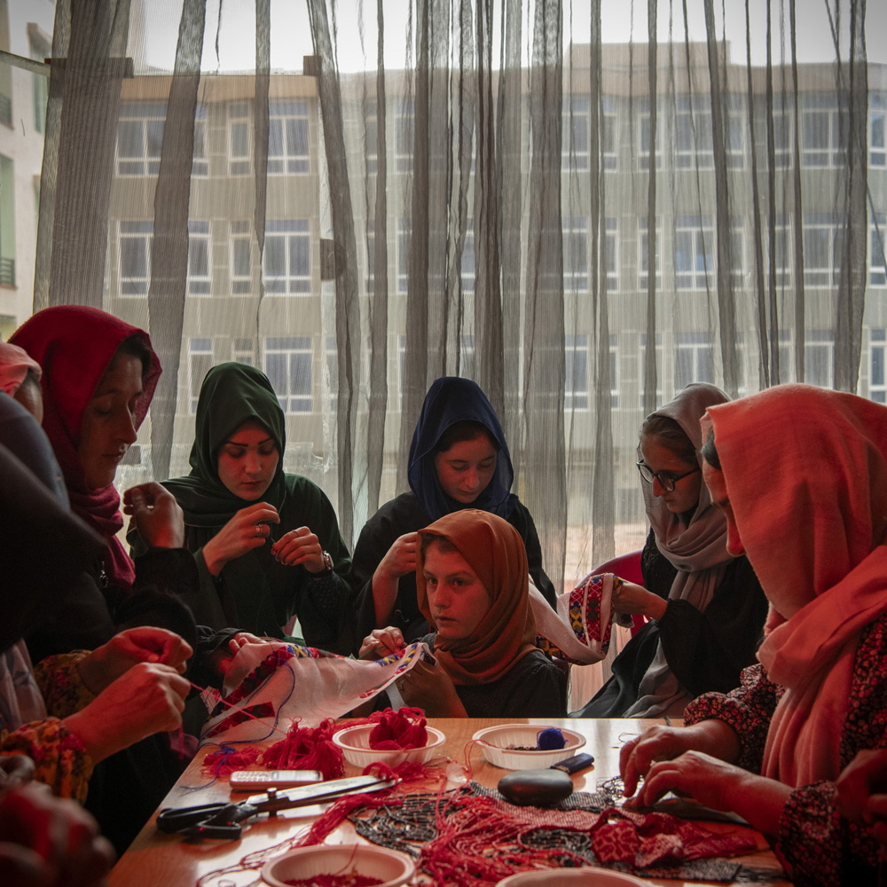
Zibak, Badakhshan, Afghanistan, May 11, 2024. Young women make traditional Badakhshi beadwork in Faizabad’s women-only market. © Kiana Hayeri for Fondation Carmignac
SB: That gives me the chills. You did that yourselves?
MC: We did that ourselves. Because the project was funded by a French foundation, and because I’m French, we really leveraged and used our networks.
SB: That’s so amazing! Congratulations and thank you so much for taking the time to talk with me.
And here’s a link so Lenscratch readers can support your efforts to help settle Fatima Bahnia in France.

Polaroid by Mélissa Cornet
Kiana Hayeri grew up in Tehran, Iran, and moved to Toronto as a teenager. She took up photography to bridge cultural and linguistic gaps. In 2014, she moved to Kabul, staying for eight years. Her work often explores migration, adolescence, identity, and sexuality in conflict zones. Kiana has received numerous prestigious awards, including the Tim Hetherington Visionary Award (2020), the James Foley Award for Conflict Reporting (2020), the Robert Capa Gold Medal (2021), and the Leica Oskar Barnack Award (2022), the Carmignac Photojournalism Award (2024), and the World Press Photo Prize (2025). She was part of The New York Times team that won The Hal Boyle Award (2022) and was shortlisted for the Pulitzer Prize in International Reporting in the same year. In 2024, she published a photobook “When Cages Fly” which was shortlisted for Rencontres d’Arles Author Book Award, IPA Photobook Awards, a finalist for Lucie Photobook Award and APhF Pick:24 Book Award and the winner of The Photography Book of the Year by POY (Picture Of the Year).
Kiana is a TED fellow, a National Geographic Explorer grantee, and a regular contributor to The New York Times.
She is currently based in Sarajevo, covering stories from Afghanistan, Syria, the Balkans, and beyond. In 2024, she was the laureate of the 14th edition of the Carmignac Photojournalism Award for No Woman’s Land.
Instagram: @kianahayeri
Mélissa Comet is a women’s rights researcher who lived and worked in Afghanistan between 2018 and 2024. Prior to the regime change of August 2021, she researched women’s economic empowerment, their involvement in elections, in the peace process, violence against women, among other topics. After the fall in August 2021,
Mélissa continued to document the degrading situation of the rights of Afghan women and girls, publishing on the impact of the food crisis on women and girls, on the mental health situation of women, and on women’s economic empowerment programs in a country where they are no longer allowed to study or move without a
Chaperon.
In 2024, Mélissa was the laureate with Kiana Hayeri of the 14th edition of the Carmignac Photojournalism Award for No Woman’s Land.
She is a cited expert on the issue of women’s rights in the country, and has been interviewed by media outlets including The Guardian, BBC, VOA, The Times and Frontline, as well as numerous French newspapers. She has appeared on ABC News, MSNBC, France 24, BFM TV, or Arte, and has been a guest speaker for events at the House of Commons and at the U.S. Institute of Peace.
Instagram: @melissacrt
Sara Bennett, a contributing editor to Lenscratch, is a 2024 Guggenheim Fellow in photography. Her first monograph, Looking Inside: Women with Life Sentences, is being published by Kehrer Verlag, and will be released on September 8, 2026.
Instagram: @ sarabennett
Posts on Lenscratch may not be reproduced without the permission of the Lenscratch staff and the photographer.
Recommended
-
Curran Hatleberg: Blood GreenMarch 9th, 2026
-
Kiana Hayeri: No Woman’s LandMarch 8th, 2026
-

McCall Hollister in Conversation With Douglas BreaultMarch 6th, 2026
-
Greg Miller: Morning BusMarch 5th, 2026
-
Vaune Trachman: Now IS AlwaysMarch 3rd, 2026


