The Art of Documentary Photography: Louie Palu

©Louie Palu, Canadian soldiers build igloo’s as an improvised survival shelter near a camp at the Crystal City training in Resolute Bay below -50 degrees Celsius in Nunavut, Canada.
The photographers we are featuring over the next few days are exceptional documentary photographers and photojournalists. What really stands out is their ability to capture reality and translate it into something poetic and powerful. They are successful because of their extraordinary powers of perception. They often work under the toughest of conditions and are forced to make quick decisions on framing, light and gesture. They tackle subjects that are sensitive and complex. Their photos are often hypnotic, mysterious and emotional.
These photographers are successful because they are always in command of the scene. They have a clear vision of what they want to say. And they see things others miss.
When I was a reporter, I worked with some of the best photojournalists and documentary photographers in the business. What struck me was how present they were, how they connected with people. I was always amazed when we would work a big crowd, they could spot the person who would open up, who had a gripping story to tell.
With so many complicated issues facing us, it seems crucial to have probing photographers bringing clarity to these debates.
Louie Palu is a Canadian/American photographer and filmmaker whose work has examined social political issues including war, resource extraction, and climate change for 30-years. He has been selected for a John Simon Guggenheim Foundation Fellowship, World Press Photo, and Best of Photojournalism awards. For the past 10-years he has focused on the changing geopolitics in the Arctic and effects on indigenous communities in the high North. His work has been widely published, and his documentary films have been broadcast and screened worldwide. Louie’s work has appeared in Bloomberg, The New York Times, The Washington Post, National Geographic, The Guardian, PBS, and BBC. His work is held in numerous collections including the Museum of Fine Arts Boston and National Gallery of Art. He is a graduate of the Ontario College of Art and Design and holds an MFA from the Maryland Institute College of Art.
Instagram: @louiepalu
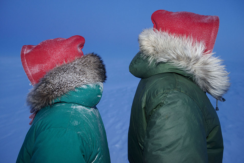
©Louie Palu, Canadian Rangers prepare to train non-indigenous soldiers in Arctic survival below -60 degrees Celsius in Resolute Bay, Nunavut, Canada.
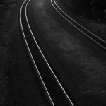
Distant Early Warning
It’s a riveting image – a lone Canadian Ranger lying in slush and ice on the shore of Clyde Inlet in the Arctic. Not another soul in sight. It is at once both peaceful and frightening. And it subtly reframes the debate over the so-called “new Cold War” in the Arctic, where environmental and security issues have been intersecting.
In this and other photos in Louie Palu’s “Distant Early Warning” project, there is little evidence of Chinese or Russian troops, or mineral mining or shipping lanes or other issues that pre-occupy the political debate in the U.S. What is overwhelmingly obvious is the fearsome power and fragility of nature.
Louie Palu began this project in 2015, making more than 40 trips to the Arctic resulting in more than 200,000 photographs.
Louie first began covering the Arctic in 1993 when diamonds were discovered in Canada’s Arctic, when he began his 12-year-long project on mining in Canada. He returned multiple times on a range of topics including issues related to indigenous communities.
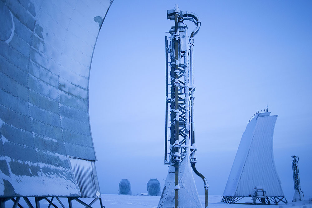
©Louie Palu, The Fox-Main Long Range Radar site, also known as Site 30 is part of the North Warning System that superseded the Distant Early Warning Line begun in 1954 to detect possible Russian missile and bomber attacks over the North Pole.
Q: What was your goal when you originally started this project?
LP: Before I understood what any goal was, I had questions. There was a specific narrative that got me to the Arctic. After photographing in Afghanistan for five years and the US Mexico Border for three I saw a seismic geopolitical shift underway and it was not in parts of the world we normally associate with conflict like the Middle East. From my ground view of what I was seeing, the Cold War never ended. When I made a film in in 2016 in Ukraine, what I saw confirmed some of my ideas. The Cold War had evolved into something new and it was emerging in the Arctic, a region that should be at the core of any discussion on climate change. I guess my goal was to answer some questions and learn how to see what was going on there in a new way. The result was communicating that nature is “the most” (not “more”) powerful force in our world.
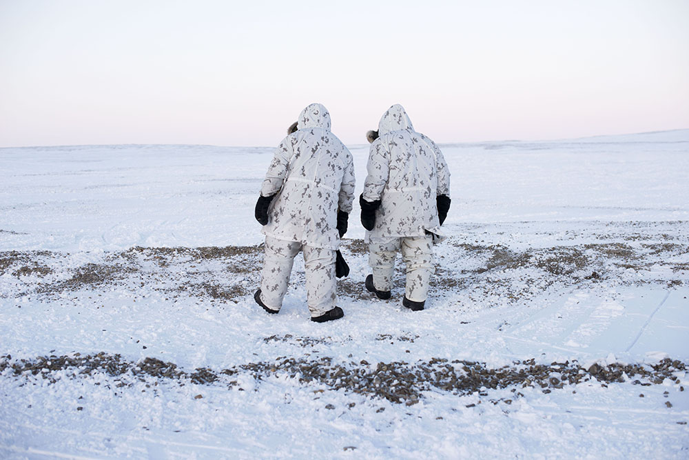
©Louie Palu, Canadian Arctic Operations Advisors walk on the shore of a lake on Cornwallis Island in Nunavut, Canada.
Q: Have the security narratives and the environmental narratives evolved? Has your view of the Arctic or the goal of the project changed?
LP: The security narratives related to protecting or preparing ourselves for climate change for me remain the same. The effects of climate change are the single greatest threat to humankind and the manipulation of information related to it works hand in hand. If you are in business and government, you should pay close attention to what’s unfolding because there will be no economy if weather destroys everything we need to survive. Something became clear to me during this project, we are not destroying the planet, we are destroying the environment we as humans need to exist. The planet will continue on without us, even if it becomes uninhabitable. From that understanding of what I was seeing I realized my photographs were images of weather and how we are challenging something much more powerful than us.
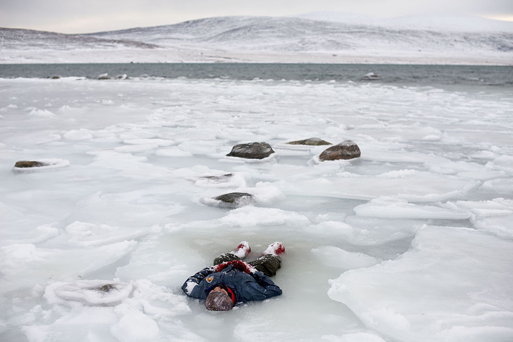
©Louie Palu, A Canadian on the shore of Clyde Inlet while training for search and rescue operations in the Inuit Hamlet of Clyde River on Baffin Island in Nunavut, Canada.
Q: The Arctic is often described as a national security story. You have reported from countries at war. Can you compare the experience?
LP: The Arctic is not one place or one thing; it can fit into over 100 different narratives. In my experience there are new and old conflicts going on we can’t see or have lost the ability to understand. The effects of colonialism in Canada’s Arctic are still unresolved, the early “exploration” of the North American Arctic were 19th century military lead operations for economic gain. Today there is a form of hybrid, asymmetrical, and unconventional warfare underway in the Arctic. There has been GPS jamming and communication cables being cut as a form of sabotage. There have been many cases of espionage within both military and civilian institutions related to polar security. Let’s think of the Chinese “weather balloon” incident as a start. There has been election and political interference as psyops and disinformation campaigns upending policy and science. I have been focused on understanding what the fallout long-term might be from the Ukrainian drone attacks on Russian Arctic bases where bombers stage for attacks. There is a lot more going on, those are only the highlights, so they are comparable, but the stakes are much higher, consider the Arctic as a place where superpowers are all directly competing, and nuclear submarines are common.
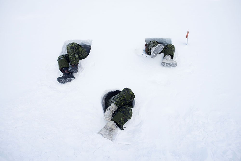
©Louie Paul, Canadian soldiers tunneling into the side of a hill creating a snow cave in Resolute Bay, Nunavut, Canada
Q: The Arctic is very big. You took thousands of photos. What do you include as influences for the story you tell. How do you edit?
LP: The Arctic is very big and is very diverse in many ways. What most influenced me in the stories I tell include from a very young age my father taking me on the land hunting and fishing in Northen Ontario. He introduced me to indigenous communities and taught me survival skills. Ice fishing and being out in -30 degrees as recreation was a normal way of life for me, I like the cold. He taught me how to respect the forces of nature including wildlife. As a parallel he was a child in Europe during the Second World War and his friend was a prisoner of war. Looking back many of the survival skills that influence me that I learned from them were based on surviving occupation, trauma, and war. When I started this project the first few trips I made North included simply meeting with Inuit elders to listen to what they were talking about, what they had seen, and what they were seeing, those are the deepest influences on how I think.
Most photographers and photo editors I work with edit by aesthetics like color, shape light, and some basic storytelling approaches related to traditional photojournalism, which I respect and also use in some of my daily editorial work. For this project my photo editor at National Geographic, Sadie Quarrier and I came up with a theme of the “unknown” which we liked to think about while we selected photos, sequenced them and what knowledge in the process I took back into the field after editing some previous trips. Our unknown future guides the editing of this project to this day.
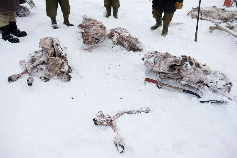
©Louie Palu, Caribou body parts stored on the tundra as emergency food are divided amongst Canadian Rangers at a temporary military camp built by indigenous soldiers outside the community of Gjoa Haven, Nunavut, Canada.
Q: How much time did you spend with the Inuit and what did you learn from them?
LP: On this project there were very few trips North in which I did not spend time with or was with full time learning from indigenous communities.
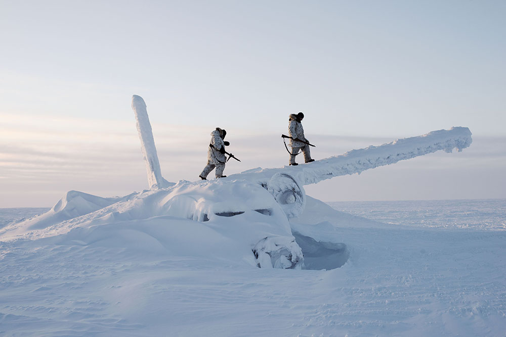
©Louie Palu, Canadian soldiers on reconnaissance on the wreckage of an airplane on Cornwallis Island in Nunavut, Canada.
Q: I think many photographers here would love to know the logistics of photographing in the Arctic. Did your camera or lens malfunction? Did you get frostbite? Was it dangerous?
LP: The Arctic can be a power that can you wield if you respect it. Then again sometimes it’s just overpowering, which is when you need to acknowledge a higher power. My cameras Nikon D800’s (which I still use) were fine except if you breathed into the back of the body while looking through the finder, as your breath would send condensation into the camera causing parts to freeze. So now I hold my breath while taking most photographs. The batteries and lubrication in the lenses could also have trouble at times, but I carry 10 batteries, 3 camera bodies and two of every lens. With a few exceptions nearly this entire project was completed with a 50mm and 28mm lens. I think my hands freezing slowly nearing a state of frostnip was normal, that’s the stage before frostbite was always a line I played with, overall, I had no serious issues. I never got frostbite, but I saw many people succumb to it. The only dangerous thing that happened to me was being in a few snowmobile accidents. But I think I am built differently than some. When I was a boy, I remember following my father duck hunting on a cold winter day, the lake had not frozen yet. He asked me if I knew how cold the lake water was and I think I stared at him blankly, he grabbed and held onto me, then pushed me in. I’ll never forget him teaching me how freezing cold the water was and not to fall in the lake. My boots were full of water and pants wet. I walked around the forest wet in the cold all day, over the years I learned to like being uncomfortable, that helps me think better.
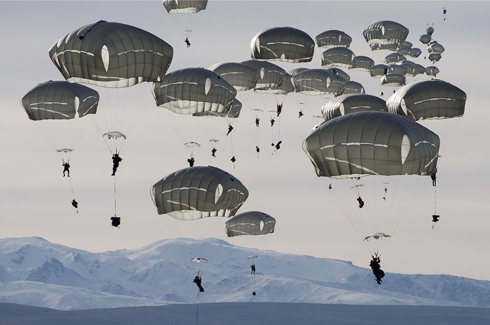
©Louie Palu, U.S. soldiers parachute onto the Donnelly Training Area near Fort Greely, which is a US Army launch site to counter ballistic missiles.
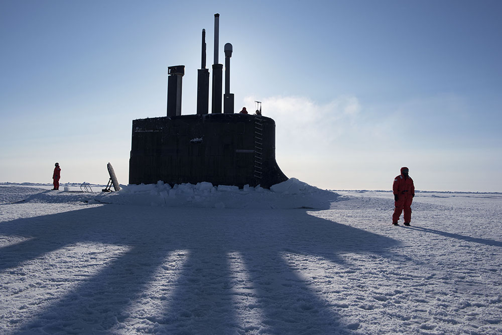
©Louie Palu, A U.S. Navy nuclear-powered attack submarine, surfaced through the ice in the Beaufort Sea during weapons testing north of Prudhoe Bay, Alaska, United States.
Posts on Lenscratch may not be reproduced without the permission of the Lenscratch staff and the photographer.
Recommended
-
Lauri Gaffin: Moving Still: A Cinematic Life Frame-by-FrameDecember 4th, 2025
-
Dani Tranchesi: Ordinary MiraclesNovember 30th, 2025
-
Art of Documentary Photography: Elliot RossOctober 30th, 2025
-
The Art of Documentary Photography: Carol GuzyOctober 29th, 2025
-

The Art of Documentary Photography: Matt McClainOctober 28th, 2025


